Revised version September 2022
Text and pictures by Malcolm Peel
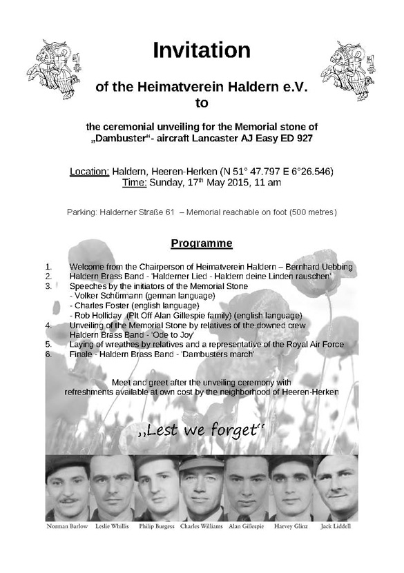
On the evening of 16th May 1943, 133 aircrew in 19 Lancasters took off from RAF Scampton in Lincolnshire to attack the German dams east of the Ruhr. Eight aircraft and 53 men did not return. Three men survived their crashes and became Prisoners of War.
The following guide to these sites was initially compiled in August 2018 and was substantially revised in September 2022. They serve as as an update to the excellent book written by Chris Ward and Andreas Wachtel, Dambuster Crash Sites, published in 2007 by Pen & Sword. Reference to this book is highly recommended for its historical content and descriptions of the discovery of the sites.
However, due to the ravages of time over the years, the construction or demolition of buildings, the changes in road layouts and other key landmarks, some of the Tour Guides in the book have become awkward to follow. Also, the book was published before the era of sat nav and Google Maps. For ease of navigation, the co-ordinates for all the sites (or the nearest vehicular access point) are given below, as well as some for key points on some routes.
If you are travelling from the UK, it is suggested that you travel to the dams first, joining the Corridor at the Möhne. To simplify its compilation, the following guide has been presented in that order as this route can also avoid using the very busy motorway network through the Ruhr around Essen, Duisburg and Dortmund.
Many users of this Guide will have a mobile navigation device of some description and therefore may only be using the co-ordinates given to each location. This might mean that you may be approaching the memorial from a different direction, which renders the detailed routes irrelevant.
However, if you are using them, they have been described from either the nearest town/city or from a major location, i.e. road junctions, castle, dam, etc., as one never knows when your sat nav is going to let one down! Also, it’s always good to have some indication that you are on the right road so, sometimes, landmarks are identified along the way.
Of the many books written about the raid, one of the best is James Holland’s Dambusters: The Race To Smash The Dams, Transworld Publishers 2012, which explains in a very readable format the reasons for the raid, the development of the bouncing bomb, the formation of 617 Squadron and the raid itself. There are also some excellent maps, diagrams and a complete Timeline of Operation Chastise.
Mention must also be made of Charles Foster’s very informative work, The Complete Dambusters: The 133 Men Who Flew on the Dams Raid, History Press 2018, which gives the story of each of the airmen who took part in the raid. A photo of each man is included as well as much information on the raid itself.
The Crash Corridor
Ward/Watchel describe in great detail how and why each aircraft crashed.
Hopgood at Soest was the only one to be shot down while attacking a dam – all the others were the victims of flak or a crash on the flight either to or from the dams. The only two not in the Corridor are shown with a cross on the above map – Byers in the sea off Texel, north of Den Helder and Burpee who crashed on the air base at Gilze-Rijen, between Breda and Tilburg.
The Dams
The co-ordinates for the three main dams are as follows:
Eder
51.184559
9.060715
Sorpe
51.353044
7.964041
Möhne
51.491659
8.061964
The Cemeteries
The casualties are buried in five cemeteries in Germany and Holland.
Rheinberg War Cemetery:
Hopgood and crew
Reichswald Forest War Cemetery:
Maudslay and crew
Astell and crew
Barlow and crew
Ottley and crew
Bergen-op-Zoom War Cemetery:
Burpee and crew
Bergen General Cemetery:
Young and crew
The grave of James McDowell, Byers’ rear gunner, is in Harlingen General Cemetery (see below) – the bodies of the rest of Byers’ crew were never recovered and they are remembered on the RAF Memorial at Runnymede. There is now a memorial to them in Harlingen General Cemetery.
The Commonwealth War Graves Commission website gives full details of all those killed and includes maps and co-ordinates for the cemeteries.
******
Flt Lt J.V. Hopgood DFC & Bar
ED925 AJ-M
Near Soest, NW of Möhnesee
Co-ordinates:
51.535276
7.996486
The most logical route to this site is from the dam. Turn right out of the car park and proceed towards Möhnesee, passing the Hotel Haus Delecke on your right.
At the roundabout, turn left onto the 229 and after about 2.0 miles, left onto the 516 towards Ense … it’s one of those weird junctions that takes you under the 516, turns left then right.
After 3.5 miles, turn right onto the L745 An Der Lanner towards Volbringen.
After passing through the village, you will come to a crossroads with a stone tower on the right … go straight on.
In less than a mile, look for some low, dark green farm buildings on the left and just before a bridge under the motorway, turn right onto the track on the right (above co-ordinates refer). This track is initially tarmac but that soon becomes stony.
The track drops down with a wood coming up your left but before the road rises again, look left … about 100 yards across some open ground, you will see a tall yellow pole and just beyond and to the right, the wooden post with a brass plaque adjacent to a wooden bench.

It is strongly advised that you do NOT attempt to cross the open ground to the memorial by car as the ground is very uneven and probably water-logged in bad weather.
Park on the right and walk up the rise – at the top, a further track on the left will take you down to the memorial.

This is the closest accessible point to the crash site which is probably in the field off to the right where the motorway runs now.
******
Plt Off W Ottley DFC
ED910 AJ-C
North of Hamm
Co-ordinates (nearest vehicular access):
51.724373
7.792254
This is one where you’ll need hiking boots or wellies!
Take the B63 north out of Hamm towards Munster, crossing over the river Lippe, and after about 1.5 miles, look out for the KAUFLAND superstore on your left.
Straight on at the next roundabout … the one with the pink elephant wearing headphones (I kid you not!)
Through the traffic lights with MANSFELDERSTR and the SENIORENZENTRUM ST JOSEPH on your right.
After about one mile, a small signpost for GEINEGGE comes up on your left … which is both a street name and a village … and on your right is a red-brick house.
SLOW DOWN.
On the right and immediately after the house is a field with an electricity pylon.

The track to the crash site is at the far end of this field just before a line of trees and runs at right-angles to the main road.
It is suggested that you reverse into this track but do NOT attempt to drive further unless you have a 4X4 or similar vehicle.
Walk down the track passing the pylon on your right … it has a black and yellow sign carrying the number 1614. If it doesn’t, you are in the wrong field!
Carry on to the corner of the wood in front of you.

The track bends left and right around the corner of the wood – amongst the trunks of two trees on the left, there are the remains of a wooden structure of some description.
Follow the line of the wood on your right for about 200 yards and the wooden cross is on your right in front of the crater created when the Upkeep exploded on impact.
Depending on the season, the ground leading up to the memorial could be very overgrown so great care should be taken.
The original memorial was situated in the crater which frequently becomes water-logged and the cross became rotten.

The bronze plaque (now barely legible) which was attached to the first cross is now fixed to the rear.
In the Spring of 2022, the area around the memorial was cleared by a local community group and consideration is being given to relocate it to a more accessible site. However, negotiations are still in the early stages and nothing is likely to occur for some time.
******
Flt Lt W Astell DFC
ED864 AJ-B
North of Raesfeld
Co-ordinates (memorial site):
51.808419
6.868116
From the Castle in Raesfeld, turn right at the roundabout and follow the road through the town. Following the B70, turn left at the roundabout north towards Borken with the Ford dealer, Autohaus Jacobs, on the left.

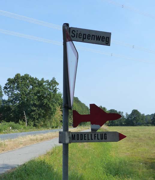
Across a second roundabout and after about 1.5 miles, straight on at the lights. About 100 yards further on, look for SIEPENWEG, a narrow tarmac road on the right.

After 200 yards, fork left – following Siepenweg.
After about ½ mile, fork right onto HESSEBREE.
Straight on at a crossroads and over a small bridge with a 9-ton weight limit.

1.8 miles later, turn right onto HUNGERWEG and the memorial is on your left.
If you stand with your back to the memorial, at 2 o’clock, you will see an electricity pylon – it is conceivable that the 1943 version of this finally brought down the Lancaster which crashed in the field behind the memorial.
******
Flt Lt R N G Barlow DFC RAAF
ED927 AJ-E
Haldern, near Rees
Co-ordinates (blue RAF sign):
51.792133
6.440214
Co-ordinates (larger parking area):
51.796722
6.448845
Co-ordinates (memorial site):
51.79662
6.442784
Major road/rail construction work is taking place near the railway station in Haldern, and it is reported that the work will continue into 2024.
Although not the shortest route, but certainly the easiest, is to take the A3 autobahn, leaving at Junction 4 and joining the 67 southbound towards REES.
In about 1.5 miles, turn left onto L549 HALDERNER STR and then after about one mile, take the narrow tarmac road to your left … an Air Force blue signpost with the RAF roundel is pointing your way! (Co-ordinates above)

About 500 yards along this road, you see a cycle path on the left with a barrier blocking vehicular access – this marks the start of the field in which Barlow’s Lancaster crashed.

The memorial is near the wind turbine to the right of the trees in the photo but for now, carry straight on to another turbine. The area in front of the turbine is/was partially fenced off but parking is still possible.
The plane crashed somewhere between the base of this turbine and the small, stagnant pond in the little field on the other side of the wire fence.
Walk or drive back to the cycle path – parking is possible – JUST!
Go down the path until you reach a rectangular field with the above turbine at 3 o’clock.
Either walk diagonally across or around the field to the memorial at the foot of a tree in the corner.

******
Sqn Ldr H E Maudslay DFC
ED937 AJ-Z
North east of Emmerich
Co-ordinates (memorial site):
51.8565
6.276442
From the A3 motorway, take Exit 3 A220 south towards Emmerich and Kleve.
The above co-ordinates may now instruct you to turn left at the KUSTER OIL filling station on the left – this route will still take you to the memorial but over some narrow tracks and blind corners/junctions. You are advised to carry on and …
… at traffic lights, with another KUSTER OIL/SPIEL STATION at 2 o’clock, turn left onto L16 WESELER STR
After about a mile, look out for the big orange OBI superstore and turn left at the roundabout.
Drive past the INTEROVO Egg Group and just before the CONVENT warehouse, turn left onto BUDBERGER STR
Fork left onto FLASSERTWEG and follow this road until you come to a left-and-right bend in the road with a red and white barrier ahead.

******
Plt Off L J Burpee DFM RCAF
ED865 AJ-S
On the former Luftwaffe night fighter station at Gilze-Rijen
Co-ordinates (entrance to airbase):
51.577043
4.926065
This memorial was dedicated in early 2018 and is situated on an active airbase operated by the Royal Netherlands Air Force.
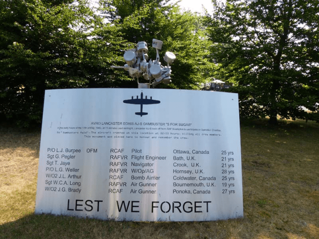
There are, as one can imagine, very tight security implications in gaining access to the base and the best way to arrange a tour is to contact Ton Van Den Hoof at the museum, giving at least two months’ notice of an intended visit. Email traditiekamer.gilzerijen@mindef.nl. It is also recommended that you email Sander van der Hall, a local supporter of the project: sandervanderhall@home.nl
However, be advised that entry permission may be withdrawn or postponed (perhaps at very short notice) should an emergency situation arise.
A tour will also include a visit to the museum which, although concentrating on the very interesting history of the airbase, has an excellent section containing Dambusters memorabilia.
******
Sqn Ldr H M “Dinghy” Young DFC & Bar
ED887 AJ-A
In the sea off Castricum-aan-Zee, Strand
Co-ordinates (nearest vehicular access):
52.5574
4.610735
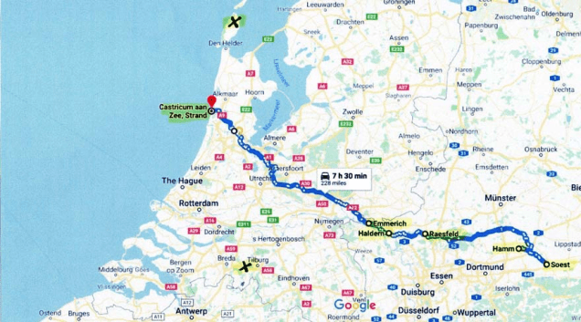
Castricum-aan-Zee is on the coast approx. 25 miles north west of Amsterdam.
Take the A9 north from Haarlem and at Junction 10, turn left onto N203.
After approx. 3.5 miles, turn left onto N513 SEEWEG
This road only goes to the Strand, a very popular beach with two huge car parks.
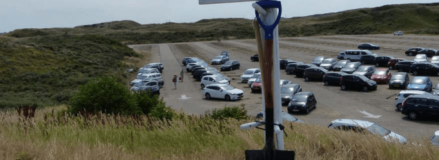
This was taken on a Friday afternoon in June 2018 and the other car park was almost full. GO EARLY OR OFF-SEASON. Parking charges apply but there’s no alternative unless you have a Disabled Badge.
Walk past the cafes; the memorial is on the left at the start of the slope down towards the beach.

******
Plt Off V W Byers RCAF
ED934 AJ-K
In the sea, off Texel/Vlieland
Co-ordinates (nearest vehicular access)
53.177619
5.424722
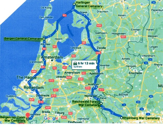
The memorial is in Harlingen General Cemetery is located in the north of the town on BEGRAAFPLAATLAAN and parking is possible nearby on MIDLUMERLAAN.


On entering the cemetery and after approx. 50m, turn left and follow the path to the CWGC graves – the memorial to the whole crew is just beyond, adjacent to the boundary.
Only one body was recovered, that of JAMES McDOWELL, the rear gunner. He was presumably thrown clear and the strong current took his body north. It was found floating in the Vliestrom Channel on 22 June 1943. It was brought ashore and he is buried in Plot E Row 4 Grave 11. The remaining bodies were never found and they are officially listed as ‘missing, presumed dead’.
As previously mentioned, the above guides were compiled in July 2018 and updated in September 2022 and while every care has been taken to provide accurate information, responsibility cannot be accepted for changes in buildings or other structures, road layouts and signage, natural and other landmarks, or any other factors used to describe routes.