Wikipedia: a foundation stone for the free internet

Stepping away from the normal terrain for this blog, this is a personal plea for all readers to support the annual appeal for the wonderful Wikipedia operation. I use Wikipedia every day, and every day I marvel at the breadth of knowledge and information contained in its 5,708,282 pages*. I’m sure many of you reading this feel the same – Wikipedia is the fifth most visited site on the internet, and the only one of the top five which doesn’t depend on advertising for income. It is a non-profit company, written and compiled by hundreds of thousands of contributors.

For many years, I noticed the occasional appeal for funds but never bothered with them. However, I now realise that it is vital for the future of the internet that this non-profit community-run venture survives and thrives. The original idea of the founders of the internet was to provide free access to information to anyone with a connection. Nothing exemplifies that idea better than Wikipedia. Like other community-driven ventures such as Parkrun, they are run by users rather than producers, by volunteers rather than professionals, they have a horizontal rather than hierarchical structure, and they’re not primarily about making money. All this was noted in an interesting article in Wednesday’s Guardian.

In order to survive financially Wikipedia depends entirely on voluntary support. So, if you are a regular user like me, please do what I have done for the last few years – make a small annual donation. Respond when the popup appears on your screen or go to the donation page.

*The number quoted on the intro page on 30 August 2018.

Dams Raid 75th anniversary: Canada remembers

Pic: Jim Heather

Great picture of the Lancaster at the Bomber Command Museum of Canada in Nanton, Alberta, which organised an event to salute the Canadian Dambusters this weekend. The Lancaster’s code letters have been changed to AJ-M, to match that carried by John Hopgood’s aircraft on the Dams Raid and it carries a full size replica of the Upkeep mine which was dropped by Hopgood at the Mohne Dam.

The picture was taken by Jim Heather, the nephew of Ken Earnshaw, Hopgood’s navigator. He also appears in this CBC news report.

Other relatives of Dams Raid participants also attended the event, and it saw the launch of a new book, The Dambusters: Canadian Airmen and the Secret Raid Against
Nazi Germany
, by Ted Barris, about the men who took part. More details on the BCMA website here.

Public viewing day for 1941 test model dam

Pic: BRE

The UK-wide’s annual Heritage Open Day on Saturday 8 September means the public get their once-a-year chance to see the very first (and only surviving) test model of the Möhne Dam, used in the very early stages of the development of what became the Dambusters’ bouncing bomb. This is housed at the premises of the Building Research Establishment at Garston, near Watford.

This free-to-attend event will not only allow access to the model dam, with talks on BRE’s role in the story repeated through the day, but also allow behind-the-scenes access to many of BRE’s current test facilities.

There will be talks and presentations repeated through the day about the role of BRE in the Dambusters raids, and also about the B17 Bomber ‘Choo-z-suzy’ that crashed on the site in 1943.

The story of how the BRE became involved is because of the friendship of two men who had met while studying engineering at Queen Mary College, University of London. They were Norman Davey, who was one of the then Building Research Station’s first staff, joining as a research assistant in November 1921. His colleague William Glanville joined as an engineering assistant in November 1922. Glanville left BRS in 1936, to become a Director of the newly-formed Road Research Laboratory at Harmondsworth in Middlesex.

At the outset of the war a team of BRS engineers, who had been working on the effects of explosives on structures since before the war, were transferred to the Road Research Laboratory. Led by A.R. Collins, they had also identified the Möhne Dam as a possible target.

Hearing about this work, Barnes Wallis met Collins and Glanville, along with Dr A.H. Davis, RRL’s assistant director, and they discussed how much damage would be caused if a large explosion occurred on the upstream side of the Möhne Dam, very close to the wall. On an unknown date in late 1940, Glanville and Wallis then held a meeting with Davey, and they decided that the most effective way to determine both the weight of explosive needed and the optimum location for it to breach the dam was to construct a scale model – and then blow it up. Davey agreed to build the model in a secluded area of the BRS’s Garston site, and so work began in November 1940. Some two million miniature concrete blocks were made, and the construction took about six weeks. The model was completed on 21 January 1941, and the first explosive test took place the following day. In all, ten explosions were carried out and the model was badly damaged. This is the model (now a listed structure) which the public can view on the Open Day.

The largest structural test hall in Britain, the wind tunnel and (possibly) the quietest place in the UK will also be open for tours and demonstrations, as will other attractions. In order to gauge numbers for the catering and (free) onsite parking, people are asked to register at the BRE website .

The first 1000 visitors through the gates on 8 September will also receive a free ticket to Grand Designs Live in London in October.

Guy Gibson’s 100th birthday

Guy Gibson with four of his Dams Raid crew. Left to right: Gibson; Fred Spafford, bomb aimer; Bob Hutchison, wireless operator; George Deering, front gunner; Harlo Taerum, navigator. The Dams Raid was the only occasion on which all seven men who made up his Dams Raid crew ever flew together operationally. Pic: IWM TR1127.

Today is the hundredth anniversary of the birth of Guy Gibson.

The following text is taken from my recently published book, The Complete Dambusters, published by History Press in 2018.


Wg Cdr G.P. Gibson VC, DSO and Bar, DFC and Bar

Guy Penrose Gibson was born on 12 August 1918 in Simla, India, where his father Alexander James (A.J.) Gibson worked for the Imperial Indian Forest Service. He didn’t set foot in England until he was 4 years old, when he was brought on a holiday to his grandparents’ house in Cornwall. At 6, his mother, Nora, and her three children made a permanent move back and he was sent off to boarding school: first to preparatory schools in Cornwall and Kent and then, aged 14, to St Edward’s School in Oxford.

Gibson’s time at St Edward’s was not particularly distinguished, but it was there that he first became interested in flying. Before he left, he wrote to Captain ‘Mutt’ Summers at Vickers-Armstrongs (who would later fly the Wellington which dropped the first test ‘bouncing bomb’ and then collect him at Weybridge station for his first meeting with Barnes Wallis) for advice on how to become a pilot. Summers told him that he should join the RAF. Gibson’s first application was refused but he tried again and was accepted onto the No. 6 Flying Training Course at Yatesbury in Wiltshire in November 1936. This was a civilian course, run under the RAF expansion scheme. Pilots who qualified from it were then recruited directly into the RAF and given a short service commission. Gibson became an acting Pilot Officer in early 1937, and then went off on further training until he was sent to his first posting, 83 (Bomber) Squadron at Turnhouse in Scotland, in September 1937.

In March 1938, 83 Squadron was transferred a couple of hundred miles south, to the newly refurbished RAF station at Scampton, Lincolnshire. On the day the war started, 3 September 1939, Gibson piloted one of the first nine RAF aircraft to see action in a raid on German shipping. Apart from one short break, he was to stay at Scampton, flying Hampdens, until he completed his first tour of operations in September 1940.

Although he was supposed to go on a rest period, instructing at a training unit, this only lasted a few weeks as he was drafted over to night fighters due to a chronic shortage of experienced pilots. He joined 29 Squadron in December 1940 and flew some ninety operations in Beaufighters, the last in December 1941, and was credited with several night fighter kills.

Having then been sent on instructional duties, he lobbied hard to get back to Bomber Command, where Sir Arthur Harris had just taken over as AOC. Harris knew Gibson and sent him to 5 Group, recommending that he be sent to command one of its new Lancaster squadrons. In the event, he was sent to 106 Squadron based at RAF Coningsby, who were still flying Manchesters but whose Lancasters were expected shortly.

Promoted to Wing Commander, Gibson flew his first operation in a Manchester on 22 April 1942, a ‘gardening’ trip. By July, he was flying a Lancaster, an aircraft widely regarded as a cut above anything else that had been used before. 106 Squadron moved on to Syerston on 1 October 1942, and Gibson completed his second tour in Bomber Command with an attack on Stuttgart on 11 March 1943.

He was expecting a rest from operations, but instead he was called to a meeting with the Commanding Officer of 5 Group, Air Vice Marshal Ralph Cochrane. ‘How would you like the idea of doing one more trip?’ Cochrane asked, and Gibson, who hated the idea of being away from the action, readily agreed.

Thus was 617 Squadron born, and the legend began to grow. Based at Scampton again, Gibson, with the support of two excellent flight commanders, Melvin Young and Henry Maudslay, took only two months to mould almost 150 aircrew into a force which would successfully deliver an innovative weapon against a series of targets using astonishing airmanship. On the Dams Raid, he was the first to attack the Möhne Dam, but his mine exploded short of its wall. When the next pilot, John Hopgood, was shot down in the process of dropping his mine, Gibson took it on himself to fly alongside each aircraft to divert the enemy flak as Mick Martin, Melvin Young and David Maltby each made their bombing runs. For this, and his leadership of the raid as a whole, he was awarded the VC.

After the raid, Gibson was taken off operations and was employed what was in effect a full-time publicist for Bomber Command and the RAF. He made public appearances all over the country, and was then sent on a speaking tour of Canada and the USA where he met politicians and film stars, but also found time to see ordinary people like the mother of Harlo Taerum, his navigator on the raid. He signed her scrapbook a few days before Taerum was killed, in a costly raid on the Dortmund Ems canal.

By January 1944 he was employed in a desk job in Whitehall, but his real task was to write a draft of his book, Enemy Coast Ahead. Much of the text about 617 Squadron was pulled together from material ghostwritten for him, although the earlier sections are probably Gibson’s own work. He also found time both to be interviewed for the Desert Island Discs radio programme and to be selected as a Conservative candidate for the next General Election.

He changed his mind about going into politics within a few months, but he was still frustrated about being kept off operations. By the late summer he had persuaded the authorities to let him fly on active service again, and he was assigned to an operation on 19 September 1944, to Mönchengladbach and Rheydt. Gibson was to be the controller in a 627 Squadron Mosquito, in charge of other Mosquitoes who were marking the target for the main bomber force.

What happened that night is the subject of much speculation. His aircraft crashed near Steenbergen in Holland, killing both Gibson and his navigator Sqn Ldr James Warwick. There are thought to be three possible causes. The first (and most likely) is that the Mosquito just ran out of fuel because neither Gibson nor Warwick were very familiar with the aircraft and didn’t know how to switch to the reserve fuel tank. The second scenario is that they were shot down, either by ground-based anti-aircraft fire or a German night fighter. A third possible account, that they were shot down in a ‘friendly fire’ episode by a main force bomber, has been put forward by some but there is some doubt about the veracity of the ‘confession’ of the rear gunner involved.

Gibson was admired by many of his peers and associates, but not by all of them. ‘Those who liked or loved him did so intensely,’ writes his biographer, Richard Morris. ‘More looked upon him with a wary respect. Many thought him unpleasantly rebarbative. A few found him insufferable.’ But he was a wartime warrior with a formidable record: few matched his two tours of bomber operations in Hampdens and Lancasters and ninety patrols in a Beaufighter. To quote Morris again: ‘He achieved greatness because his combat experience was backed by a practical application of rules of leadership which he had learned: the need to unify his squadrons behind clear aims, to communicate his aims with confidence and to balance discipline with the enlistment of hearts.’

Gibson is buried in the Catholic Cemetery, Steenbergen.

Dambuster Crash Sites: a driver’s guide

Pic: Malcolm Peel

Text and pictures by Malcolm Peel.

On the evening of 16th May 1943, 133 aircrew in 19 Lancasters took off from RAF Scampton in Lincolnshire to attack the dams east of the Ruhr. Eight aircraft and 53 men did not return. Three men survived their crashes and became Prisoners of War.

There are currently memorials at six of the crash sites with a seventh in the planning stage.

The following guide to these sites was compiled in July 2018 as an update to the excellent book written by Chris Ward and Andreas Wachtel, Dambuster Crash Sites, published in 2007 by Pen & Sword. Reference to this book is highly recommended for its historical content and descriptions of the discovery of the sites.

However, due to the ravages of time over 11 years, the construction or demolition of buildings, the changes in road layouts and other key landmarks, some of the Tour Guides in the book have become awkward to follow. Also, the book was published before the era of sat nav and Google Maps. For ease of navigation, the co-ordinates for all the sites (or the nearest vehicular access point) are given below.

If you are travelling from the UK, it is suggested that you travel to the dams first, joining the Corridor at the Möhne. To simplify its compilation, the following guide has been presented in that order. This route can also avoid using the very busy motorway network through the Ruhr around Essen, Duisburg and Dortmund.

Of the many books written about the raid, one of the best is James Holland’s Dambusters: The Race To Smash The Dams, Transworld Publishers 2012, which explains in a very readable format the reasons for the raid, the development of the bouncing bomb, the formation of 617 Squadron and the raid itself. There are also some excellent maps, diagrams and a complete Timeline of Operation Chastise.

Mention must also be made of Charles Foster’s very informative work, The Complete Dambusters: The 133 Men Who Flew on the Dams Raid, History Press 2018, which gives the story of each of the airmen who took part in the raid. A photo of each man is included as well as much information on the raid itself.

The Crash Corridor

Ward/Watchel describe in great detail how and why each aircraft crashed.

Hopgood at Soest was the only one to be shot down while attacking a dam – all the others were the victims of flak or a crash on the flight either to or from the dams. The only two not in the Corridor are shown with a cross on the above map – Byers in the sea off Texel, north of Den Helder and Burpee who crashed on the air base at Gilze-Reisen, between Breda and Tilburg.

The Dams
The co-ordinates for the three main dams are as follows:
Eder
51.184559
9.060715

Sorpe
51.353044
7.964041

Möhne
51.491659
8.061964

The Cemeteries
The casualties are buried in five cemeteries in Germany and Holland.

Rheinberg:
Hopgood and crew

Reichswald Forest:
Maudslay and crew
Astell and crew
Barlow and crew
Ottley and crew

Bergen-op-Zoom:
Burpee and crew

Bergen General Cemetery:
Young and crew

The grave of James McDowell, Byers’ rear gunner, is in Harlingen General Cemetery – the bodies of the rest of Byers’ crew were never recovered and they are remembered on the RAF Memorial at Runnymede.

The Commonwealth War Graves Commission website gives full details of all those killed and includes maps and co-ordinates for the cemeteries.

******

Flt Lt J.V. Hopgood DFC & Bar
ED925 AJ-M
Near Soest, NW of Möhnesee
Co-ordinates (nearest vehicular access):

51.535638
7.999639

The most logical route to this site is from the dam. Turn right out of the car park and proceed towards Möhnesee, passing the Hotel Haus Delecke on your right.

At the roundabout, turn left onto the 229 and after about 2.0 miles, left onto the 516 towards Ense … it’s one of those weird junctions that takes you under the 516, turns left then right.

After 3.5 miles, turn right onto the L745 An Der Lanner towards Volbringen.

After passing through the village, you will come to a crossroads with a stone tower on the right … go straight on.

In less than a mile and just before a bridge under the motorway, turn right onto the track on the right … initially tarmac but that soon becomes stony.

The track drops down with a wood coming up your left but before the road rises again, look left … about 100 yards across the field, you’ll see the wooden post with a brass plaque.

This is the closest accessible point to the crash site which is probably where the motorway runs now.

Should you be travelling to this site via the A44 motorway and you’re going west towards Dortmund, leave at Exit 56 (Möhnesee) and turn left onto the 229. Follow until you reach the 516, turn right and continue as above.

However, if you’re heading east towards Kassel, Exit 55 (Werl-Sud & Ense). Turn right onto the 516 which will take you (via Ense) to the left turn onto the L745 … then as above.

******

Plt Off W Ottley DFC
ED910 AJ-C
North of Hamm
Co-ordinates (nearest vehicular access):
51.724373
7.792254

This is one where you’ll need hiking boots or wellies!

Take the B63 north out of Hamm towards Munster and after crossing over the river Lippe, look out for the R.E.A.L. superstore on your left.

Straight on at the next roundabout … the one with the pink elephant wearing headphones (I kid you not!)

Through the traffic lights with MansfelderStr and the SENIORENZENTRUM ST JOSEPH on your right.

After about one mile, a signpost for Geinegge comes up on your left … which is both a street name and a village.

On your right is a house with the sign ISENBECK PILS on the front wall. SLOW DOWN.

Immediately after the house is a field with an electricity pylon at the far end.

The track to the crash site is at the far end of this field just before a line of trees and runs at right-angles to the main road. There is just enough room to park off the road.

Walk down the track passing the pylon on your right … it has a black and yellow sign carrying the number 1614. If it doesn’t, you are in the wrong field!

Carry on to the corner of the wood in front of you.

The track bends left and right around the corner of the wood – amongst the trunks of two trees on the left, there are the remains of a wooden structure of some description. Follow the line of the wood on your right for about 200 yards and the wooden cross is on your right in front of the crater created when the Upkeep exploded on impact.

The original memorial was situated in the crater which frequently becomes water-logged and the cross became rotten.

The bronze plaque (now barely legible) which was attached to the first cross is now fixed to the rear.

When this site was visited in July 2018, the area around the cross was very overgrown so before this photo was taken, time was spent clearing away some of the nettles, weeds and undergrowth. Unlike some other memorials to downed Dambuster crews, this one does not seem to be cared for by locals.

******

Flt Lt W Astell DFC
ED864 AJ-B
North of Raesfeld
Co-ordinates (memorial site):
51.808419
6.868116

From the Castle in Raesfeld, take the Sudring and the B70 through the town and keeping on the 70, turning left at the roundabout north towards Borken with the Ford dealer, Autohaus Jacobs, on the left.

Across a second roundabout and after about 1.5 miles, straight on at the lights. About 100 yards further on, look for SIEPENWEG, a narrow tarmac road on the right.

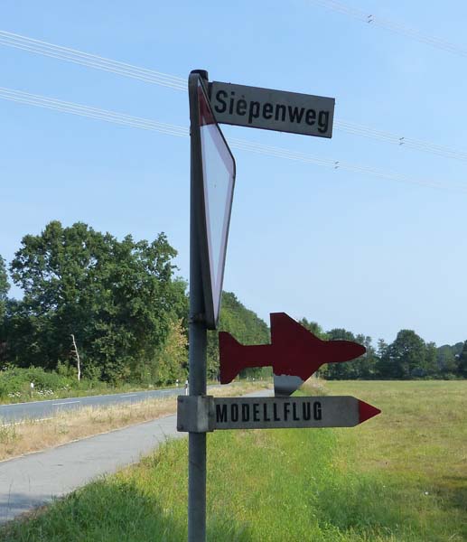
After 200 yards, fork left – following Siepenweg.
After about ½ mile, fork right onto HESSEBREE.
Straight on at a crossroads and over a small bridge with a 9 ton weight limit.

1.8 miles later, turn right onto HUNGERWEG and the memorial is on your left.

If you stand with your back to the memorial, at 2 o’clock, you will see the pylon which some say finally brought down the Lancaster.

******

Flt Lt R N G Barlow DFC RAAF
ED927 AJ-E
Haldern, near Rees
Co-ordinates (larger parking area):
51.796722
6.448845
Co-ordinates (memorial site):
51.79662
6.442784

Leave the town of Haldern with the church on your left; drive down BAHNHOFF STR and turn right just before the level crossing onto L459 HALDERN STR towards MILLINGEN.

After 1.0 mile, go straight on at the crossroads with HERKENER WEG and HEERENER WEG, where you will see a small shrine on the right.

After ½ mile, look for a small green signpost to HALDERNER STR 59 on the left, and immediately after, take the narrow tarmac road to your right.

If you reach a large, low cattleshed-type building on your left, turn around – you’ve missed the turn!

About 500 yards along this road, you see a cycle path on the left with a barrier blocking vehicular access – this marks the start of the field in which Barlow’s Lancaster crashed.

The memorial is near the wind turbine to the right of the trees but for now, carry straight on to another turbine and park.

The plane crashed somewhere between the base of this turbine and the small, stagnant pond in the little field on the other side of the wire fence.

Walk or drive back to the cycle path.
Go down the path until you reach a rectangular field with the above turbine at 3 o’clock.
Either walk diagonally across or around the field to the memorial at the foot of a tree in the corner.

******

Sqn Ldr H E Maudslay DFC
ED937 AJ-Z
North east of Emmerich
Co-ordinates (memorial site):
51.8565
6.276442

From the A3 motorway, take Exit 3 A220 south towards Emmerich and Kleve.

At traffic lights, with the KusterOil filling station at 2 o’clock, turn left onto L16 WESELER STR

After about a mile, look out for the big orange OBI superstore and turn left at the roundabout.

Follow this road until it narrows and turn left onto BUDBERGER STR

Fork left onto FLASSERTWEG and follow this road until you come to a left-and-right bend in the road with a red and white barrier ahead.

Standing with the barrier on your left, Maudslay crashed in the field to your front.

There are ongoing plans to put a permanent memorial to the crew next to the barrier.

However at the end of June 2018, a mystery tribute appeared near the site which turned out to have been placed there by a Dutch pilot based in Scotland who had done some research on the crash.

This “unofficial” memorial can be found on the right, about halfway to the barrier.

******

Plt Off L J Burpee DFM RCAF
ED865 AJ-S
On the former Luftwaffe night fighter station at Gilze-Reisen
Co-ordinates (entrance to airbase):
51.577043
4.926065

This memorial was dedicated in early 2018 and is situated on an active airbase operated by the Royal Dutch Air Force.

There are, as one can imagine, security implications in gaining access to the base and the best way to arrange a tour is to contact Ton Van Den Hoof at the museum, giving at least 14 days notice of an intended visit. Email Traditiekamer.GilzeRijen@mindef.nl

He will then be able to give an update on the entry procedure as application has been made to the base commander in an effort to simplify access.

A tour will also include a visit to the museum which although concentrating on the very interesting history of the airbase, has an excellent section containing Dambusters memorabilia.

******

Sqn Ldr H M “Dinghy” Young DFC & Bar
ED887 AJ-A
In the sea off Castricum-aan-Zee, Strand
Co-ordinates (nearest vehicular access):
52.5574
4.610735

Castricum-aan-Zee is on the coast approx. 25 miles north west of Amsterdam.

Take the A9 north from Haarlem and turn left onto N203.

After approx. 3.5 miles, turn left onto N513 SEEWEG

This road only goes to the Strand, a very popular beach with two huge car parks.

This was taken on a Friday afternoon in June 2018 and the other car park was almost full. GO EARLY OR OFF-SEASON. Parking cost €7.50 but there’s no alternative, unless you have a Disabled Badge.

Walk past the cafes; the memorial is on the left at the start of the slope down towards the beach.


******

Plt Off V W Byers RCAF
ED934 AJ-K
In the sea, off Texel/Vlieland
Co-ordinates (car park at northern tip of Texel island):
53.174453
4.867218

Texel is an island about 40 miles north of Alkmaar and is only accessible by ferry.

From the northern tip of the island, one can only look out to sea and envisage where the Lancaster crashed.

There is no memorial on land for the crew. Only one body was recovered, that of JAMES McDOWELL, the rear gunner. He was presumably thrown clear and the strong current took his body north. It was found floating in the Vliestrom Channel on 22 June 1943. It was brought ashore and he was buried in Harlingen General Cemetery.

The above guides were compiled in July 2018 and while every care has been taken to provide accurate information, responsibility cannot be accepted for changes in buildings or other structures, road layouts and signage, natural and other landmarks, or any other factors used to describe routes.